Marine forecast issued by the Solomon Islands Meteorological Service and valid for the next 24 hours from 4:00pm this afternoon on Monday, 25 May 2026.
General Situation
A trough lies just north of the Solomon Islands.
Marine Warnings
NIL
Forecast for the Western Region (Western, Choiseul and Isabel provinces)
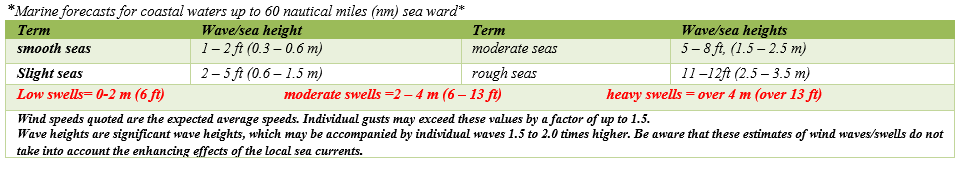
Southeast to south at 05 to 15 knots with slight seas and low to moderate southerly swells over southern waters of Western province. Scattered showers and thunderstorms. Further Outlook for Wednesday: Southeast to south winds at 05 to 15 knots and low southerly swells.
Forecast for the Central Region (Malaita, Guadalcanal and Central provinces)
Southeast to south winds at 05 to 15 knots with slight seas and low to moderate southerly swells over southern waters of Russell and Guadalcanal. Scattered showers and thunderstorms. Further Outlook for Wednesday: Southeast to south winds at 05 to 15 knots and low southerly swells.
Forecast for the Eastern Region (Makira, Temotu and Rennell/Bellona provinces)
Southeast to south winds 05 to 15 knots with slight seas and low to moderate southeast swells. Isolated showers and thunderstorms. Further Outlook for Wednesday: Southeast to south winds 05 to 15 knots and low southerly swells.
Forecast for Honiara port & surrounding areas
Northeast to east winds at 05 to 15 knots with smooth to slight seas. Fine apart from a few showers and isolated thunderstorms. Further Outlook for Wednesday: East to southeast winds at 05 to 10 knots.
Tidal Prediction for Honiara
High tide will be at 03:02am tomorrow morning (0.78m).
Low tide will be at 1:55pm tomorrow afternoon (0.43m).
Tidal Prediction for Lata
Low tide will be at 6:35pm this evening (0.43m).
High tide will be at 01:14am early tomorrow morning (1.25m).
Tidal Prediction for Taro
Low tide will be at 5:42pm this afternoon (0.54m).
High tide will be at 12:49am early tomorrow morning (1.16m).
The next update will be issued at 7:00am tomorrow morning.